Dev blog #127
24.03.2016
Hello everyone!
Today we'll tell you how the biggest landmark of the new map has been created - the city of Moscow itself.
When we started to plan the work on the map, the question 'what to do with the city?' immediately came to mind. Creation of a big metropolis with many unique objects, complex network of streets, huge factory buildings and world-known landmarks - this is a task we needed to finish in just a year and no one achieved it in a combat flight sim in such time with limited resources available before.
We had three ways to choose from:
1. Create a city from standard buildings without keeping the layout authentic and add 5-10 unique objects in the center. This approach allows to fly above the city and was used in another modern game about WWII, where main streets stop after Garden ring, layout of the city core is incorrect, the ratio betwen Garden and Boulevard rings is several times wrong, Gorky (Tverskaya) street stops at Garden ring and doesn't continue as Leningradsky prospekt, etc.
2. End the map at 20-30 kilometers to the West of the city and don't model it at all. As they say, 'what can't be cured must be endured'.
3. Model the historical layout of the city as close to real one as possible using some kind of scenery set so landmarks and city blocks will be recognizable. This means players shouldn't be able to fly above the city, because scenery objects are designed to be viewed from a distance of 5-15 km, but close up they look very simplified, too simple for a modern game.
We decided to use the third approach because of several reasons:
First, Battle of Moscow without Moscow in any form would be a bit strange.
Second, each new map should add something unique to the game world. On Stalingrad map it was the ruined city. We could create a city and make it reachable because it was in ruins already and it covered significantly smaller area - this simplified the task of creating the city blocks and made it implementable in a reasonable amount of time. On the Battle of Moscow map such object is Moscow itself of course.
Third, it would be the first historically accurate model of WWII timeframe Moscow - it is always interesting to be the first.
Fourth, this approach allowed us to create something valuable for the game and from the historical reconstruction point of view, something that would be approved by the players.
After the phase of strategic planning we needed to switch to the tactics level of development. Oddly enough, Soviet data on the city layout at that time is limited, so we used German aerial photos collected by http://warfly.ru/ website. Using these aerial photos, pre-war maps and selected historical photographs we were able to create a specification for the model of the city. We contracted a studio Yugra-Media in Khanty-Mansiysk to create it and they completed this task exceptionally well. Later we used this model and aerial photos to texture the city landscape and placed trees and roads.
Here are two images showing Moscow in the sim from 6 km altitude close to the border of reachable zone (this is like you would see the city). On second screenshot we designated the major landmarks:


Since players can fly really close to the city, its western outskirts are actually reachable and there are some interesting objects, so we created a number of unique buldings with good enough quality to be viewed up close. Regular buildings in this area aren't very high, they are of the same type like in nearby towns of Kalinin, Rzhev, Vyazma, Klin and so on, so they can be modelled using the same elements. We'll show you several examples of the detailed unique buildings:
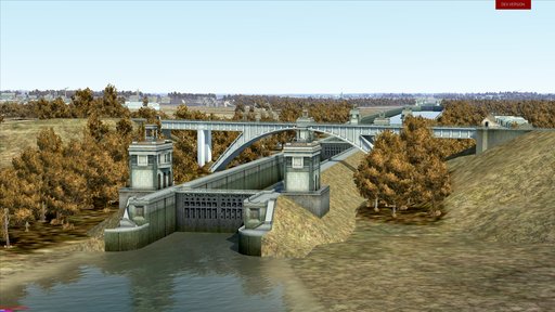
Moscow canal locks #7 and #8. Kalinin railway bridge is built above the lock #8. This is a recognizable location which looks almost the same today, with the addition on buildings nearby:

Chkalov aeroclub near Tushino airfield:

Northern River Terminal at Khimki water reservoir:

Water sports stadium Dynamo at Khimki water reservoir:

Naturally, the unreachable districts of the city situated close to playable area required more attention than others. These districts are Sokol, Airport, Fili, Voykovsky. There are important infrastructure objects, so they were modeled with middle level of detalization, allowing players to look at them using significant zoom from 1-3 km distance, examples how user can see them are next:
Voykovsky and Sokol districts. Moscow Aviation Institute is in the image center, metro depot Sokol is behind it. You can see the halls of the All-Union Agricultural Exhibition to the far left:

Sokol and Airport districts. Frunze Central Aerodrome (Khodynskoye pole) is in the image center. At the far border of the airfield, next to runway, you can see a large machine shop of the 1st Moscow machinery works "Banner of Labor", where MiG-3 aircraft were produced among other things. Now both the factory and the airfield are gone, but this machine shop is still there. You can see the distant city outline in the background with various famous landmarks visible:

Fili district. Here you can see the airfield of the Aircraft factory #22 where Pe-2 dive bombers where built. This area belongs to Khrunichev State Research and Production Space Center now, but some of these buildings are still standing:

In the end I want to say that we think we managed to create something really unique, something that wasn't done before, something that has artistic merit and educational value. Of course, we hope that the result of this work will be interesting to you - you'll be able to assess the results of our work very soon.